| Mount Beauty Weather Data | |||
|---|---|---|---|
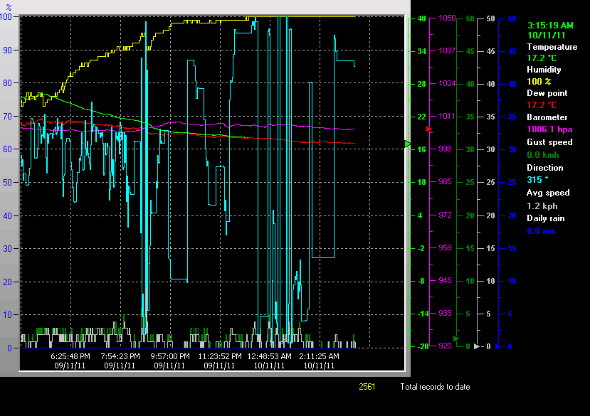
| LAST READING AT TIME: 3:15 AM DATE: 10 November 2011, time of next update: 3:31 AM | |||
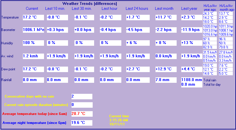
| Current Weather | Night time/Dry | Current Temperature | 17.2°C (62.9°F) (Heat Index 17.2°C ), Apparent temp 18.8°C |
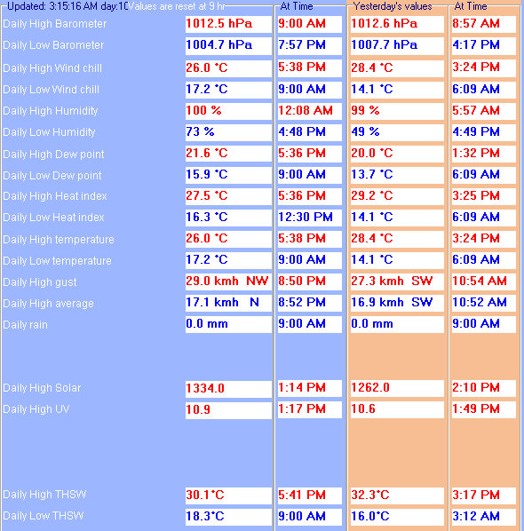
| Maximum Temperature (since 9am) | 26.0°C at: 5:38 PM | Minimum Temperature (since 9am) | 17.2°C at: 9:00 AM |
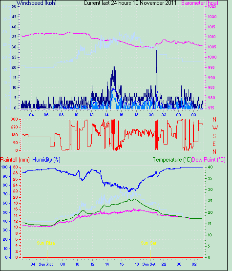
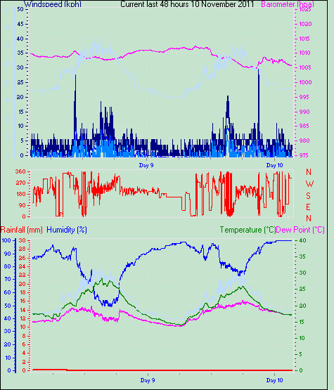
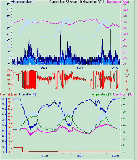
| Average windspeed (ten minute) | 0.7 kmh (0.4 kts) | Wind Direction (ten minute) | NW (315°) |
| Heat Index | 17.2°C | Maximum Gust (last hour) | 4.8 kmh (2.6 kts) at: 2:34AM |
| Maximum Gust (since 9am) | 29.0 kmh (15.7 kts) at: 8:50 PM | Maximum 1 minute average (since 9am) | 17.1 kmh (9.2 kts) at: 8:52 PM |
| Rainfall (last hour) | 0.0 mm | Rainfall (since 9am) | 0.0 mm (0.00 in.)--- |
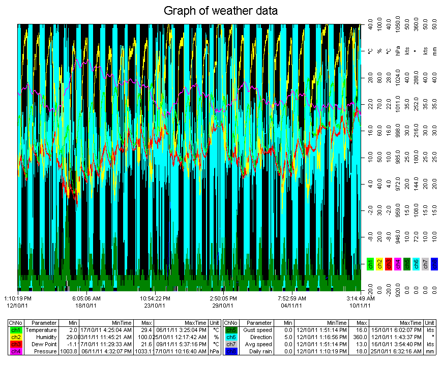
| Rainfall This month | 3.6 mm (0.14 in.) | Rainfall To date this year | 985.7 mm (38.81 in.) |
| Maximum rain per minute (last hour) | 0.0 mm/min | Maximum rain per hour (last 6 hours) | 0.0 mm/hour |
| Yesterdays rainfall | 0.0 mm | DewPoint | 17.2°C (Wet Bulb :17.2°C ) |
| Humidity | 100 %, Humidex 22.6°C | Barometer corrected to msl | 1006.1 hPa |
| Pressure change | -0.4 hPa (last hour) | Trend (last hour) | STEADY |
| Pressure change (last 12 hours) | -2.6 hPa | Pressure change (last 6 hours) | -0.7 hPa |
| Current solar | 0 W/M� | Current UV | 0.0 |
| Maximum solar (since 9am) | 1334 W/M� | Maximum UV (since 9am) | 10.9 |
| Current 00:00 hours of sunshine today, current sky: Night time/Dry | |||
| Sunshine hours for the year: | 1312:15 hrs | Sunshine hours for the month: | 57:28 hrs |
| Current evapotranspiration rate 0.1 mm per day. Yesterday's reading 2.2 | |||
IDV17005
Australian Government Bureau of Meteorology
Victoria

North East District Forecast
Issued at 5:40 am EDT on Wednesday 9 November 2011
for the period until midnight EDT Saturday 12 November 2011.

Warning Summary at issue time
Flood Watch for the Goulburn and Broken Basins.
Flood Watch for North East Victoria (Upper Murray, Mitta Mitta, Kiewa, Ovens
and King Catchments).
Severe weather warning for flash flooding within this area.
Details of warnings are available on the Bureau's website www.bom.gov.au, by
telephone 1300-659-217* or through some TV and radio broadcasts.

Weather Situation
A strengthening cold front will reach western Victoria around midday on
Wednesday then push into eastern areas Wednesday night, finally clearing from
the east on Thursday morning and an associated deep low pressure system will
pass south of Tasmania. A ridge of high pressure will extend across the
Victoria late on Thursday with a small high centre crossing to the Tasman Sea
on Friday. A weak cold front will move through Bass Strait on Saturday.

Forecast for the rest of Wednesday 9 November
Cloudy. Showers and thunderstorms developing from late morning then tending to
thundery rain later this afternoon and evening with heavy falls. Winds north to
northeasterly averaging 15 to 30 km/h tending northeast to northwesterly up to
35 km/h during the morning. Daytime maximum temperatures 22 to 28.

Albury-Wodonga      Storms and heavy rain developing.Max 29
Wangaratta          Storms and heavy rain developing.Max 28
Mount Buller        Heavy rain and storms developing.Max 17
Mount Hotham        Storms and heavy rain developing.Max 14
Falls Creek         Storms and heavy rain developing.Max 16

Fire Danger:
Low-Moderate

UV Alert from 9:10 am to 4:50 pm, UV Index predicted to reach 10 [Very High]

Forecast for Thursday 10 November
Heavy rain, easing to patchy rain around dawn, clearing around midday. Isolated
thunderstorms during the morning. Sunny afternoon. Winds west to northwesterly
averaging 25 to 40 km/h tending west to southwesterly around dawn then
decreasing below 25 km/h by early evening. Overnight temperatures falling to
between 9 and 13 with daytime temperatures reaching between 18 and 24.

Albury-Wodonga      Heavy morning rain.             Min 13      Max 24
Wangaratta          Morning rain.                   Min 12      Max 24
Mount Buller        Morning rain. Wind easing.      Min 6       Max 13
Mount Hotham        Heavy morning rain.             Min 6       Max 11
Falls Creek         Morning rain then sunny.        Min 8       Max 13

Forecast for Friday 11 November
Partly cloudy. Light winds. Overnight temperatures falling to between 5 and 8
with daytime temperatures reaching 20 to 26.

Albury-Wodonga      Partly cloudy.                  Min 9       Max 26
Wangaratta          Partly cloudy.                  Min 8       Max 26
Mount Buller        Partly cloudy.                  Min 2       Max 15
Mount Hotham        Partly cloudy.                  Min 3       Max 12
Falls Creek         Partly cloudy.                  Min 3       Max 14

Forecast for Saturday 12 November
Mostly sunny. Light winds. Overnight temperatures falling to between 8 and 11
with daytime temperatures reaching 20 to 26.

Albury-Wodonga      Mostly sunny.                   Min 11      Max 27
Wangaratta          Mostly sunny.                   Min 10      Max 26
Mount Buller        Possible afternoon shower.      Min 4       Max 15
Mount Hotham        Partly cloudy.                  Min 5       Max 12
Falls Creek         Partly cloudy.                  Min 5       Max 14

The next routine forecast will be issued at 4:15 pm EDT Wednesday.

* Calls to 1300 numbers cost around 27.5c incl. GST, higher from mobiles or
public phones.


Copyright Commonwealth of Australia 2011, Bureau of Meteorology (ABN 92 637 533
532).  Users of these web pages are deemed to have read and accepted the
conditions described in the Copyright, Disclaimer, and Privacy statements
(http://www.bom.gov.au/other/copyright.shtml).
IDV17006
Australian Government Bureau of Meteorology
Victoria

Alpine Areas District Forecast
Issued at 5:40 am EDT on Wednesday 3 November 2010
for the period until midnight EDT Saturday 6 November 2010.

Warning Summary at issue time
Minor Flood Warning for the Ovens River Minor Flood Warning for the King River.
Details of warnings are available on the Bureau's website www.bom.gov.au, by
telephone 1300-659-217* or through some TV and radio broadcasts.

Weather Situation
A large high pressure system south of the Bight will approach Tasmania on
Thursday before moving to the southern Tasman Sea on Friday night and Saturday.
A low pressure trough will be crossing South Australia later on Saturday.

Forecast for the rest of Wednesday
Partly cloudy. Isolated showers, mainly in the south. Snow above 1500 metres.
Winds southwesterly averaging 15 to 25 km/h. Temperatures around 8 during the
day.

Mount Buller        Mainly dry.                     Max 4
Mount Hotham        Partly cloudy.                  Max 4
Falls Creek         Becoming cloudy.                Max 6

UV Alert from 8:50 am to 4:50 pm, UV Index predicted to reach 12 [Extreme]

Forecast for Thursday
Partly cloudy. Winds south to southeasterly averaging 15 to 25 km/h tending
easterly about 20 km/h later in the evening. Overnight temperatures falling to
around minus 1 with daytime temperatures reaching around 5.

Mount Buller        Sunny.                          Min -3      Max 5
Mount Hotham        Partly cloudy.                  Min -3      Max 4
Falls Creek         Partly cloudy.                  Min -2      Max 6

Forecast for Friday
Partly cloudy. Winds easterly averaging 15 to 25 km/h. Overnight temperatures
falling to around 1 with daytime temperatures reaching around 12.

Mount Buller        Partly cloudy.                  Min -1      Max 9
Mount Hotham        Partly cloudy.                  Min -1      Max 8
Falls Creek         Partly cloudy.                  Min 0       Max 9

Forecast for Saturday
Partly cloudy. The chance of showers in the afternoon and evening. Winds east
to northeasterly averaging 15 to 25 km/h tending north to northeasterly up to
30 km/h by early evening. Overnight temperatures falling to around 1 with
daytime temperatures reaching around 13.

Mount Buller        Possible afternoon shower.      Min -1      Max 9
Mount Hotham        Possible afternoon shower.      Min -1      Max 8
Falls Creek         Possible afternoon shower.      Min 0       Max 10

The next routine forecast will be issued at 4:15 pm EDT Wednesday.

* Calls to 1300 numbers cost around 27.5c incl. GST, higher from mobiles or
public phones.


Copyright Commonwealth of Australia 2010, Bureau of Meteorology
(ABN 92 637 533 532) Please note the Copyright Notice
(http://www.bom.gov.au/other/copyright.shtml) and Disclaimer
(http://www.bom.gov.au/other/disclaimer.shtml) statements relating to the use
of the information on this site and our site Privacy
(http://www.bom.gov.au/other/privacy.shtml) and Accessibility
(http://www.bom.gov.au/other/accessibility.shtml) statements. Users of these
web pages are deemed to have read and accepted the conditions described in the
Copyright, Disclaimer, and Privacy statements. Please also note the
Acknowledgement (http://www.bom.gov.au/other/copyright.shtml#acknowledgements)
notice relating to the use of information on this site. No unsolicited
commercial email.